Track length: 21 km
Difficulty Level: Easy-Medium
Points of interest: Sirin Plateau, Ein Hada, Ein Olem
The Trail
This time, we will explore the springs of Ein Hada (Hadatha) and the Ein Olem, at Sirin plateau. These are natural perennial springs, named after the Arab villages, Hadatha and Olem, which existed around them until 1948. The water is collected in concrete spring boxes and nearby basins are used to water the animals.
Many travellers bathe in the basins and some soak in the water inside the boxes, entering from a narrow opening at the top (keep in mind that you’ll need assistance to get out, depending on water level inside). The water in the basins is mostly clear at Ein Hada, but only during winter at Ein Olem, when the flow is stronger.
The route starts off Safsaf road and connects further on to the blue waymarked trail, heading generally southeast. After about 6.2 km turn right on a path with cattle crossing. After about 180 m from the cattle crossing, keep right at the fork. Pass by Hadatha’s old cemetery and keep right at the crossroads. Ein Hada spring is at the end of the sharp curve to the left. You can grab a shade under the eucalyptus trees nearby or dip in the cool water.
You can go back up to the blue waymarked trail and continue from there to Ein Olem, but the path on the slope provides a better view, especially when the area is green, and a higher chance of encountering wildlife.
Return towards the cemetery and this time take the path beneath it. Proceed across the slope for about 2.17 km until the green waymarked trail. Turn right and after about 50 m turn left to go down the slope to Ein Olem.
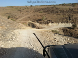
 The picture on the right shows Olem passage after rebuilding in the summer of 2014. The way which is often washed away by rainwater can be dangerous. According to updates from the net, the crossing was washed away again and impassable for vehicles. Alternatively, you can get to Ein Olen from the south, after a detour from east, on the blue waymarked trail.
Head south from Ein Olem, on the green waymarked trail, which curves east and connects back to the blue waymarked trail. Turn left and stay on that trail till you reach the red waymarked trail. Take the trail heading north and pass Sharona reservoirs to the right until the trail connects back to the blue waymarked trail. keep on that path back to Safsaf road which leads to route 767.
 Adiga Riders Adige Offroad site – Horses, 4wd and mountain bikes
